US-CANADIAN RELATIONS: Y U NO MORE INTUITIVE AND SIMPLE FOR SUCH FRIENDLY COUNTRIES?!
Things that are surprisingly easy to do:
– Withdraw from a Canadian university for medical reasons.
– Hire a company to pack all your apartment’s crap and haul it across the country for you.
– Love Coldplay’s new song Paradise. OH MY GOODNESS SO MUCH LOVE FIVE STARS FIVE STARS FIVE STARS.
Things that are surprisingly difficult to do:
– Cancel your Canadian credit card.
– Transfer Canadian funds to a US account.
– Terminate a Canadian cell phone contract.
– Send medical info from the US to Canada.
– Figure out how much money you’re getting for being a TA for part of a month.
– Doing all of the above in the exact appropriate order so that it all works out in the end.
Hooray stress! Perhaps today’s meme entry will alleviate anxiety.
30-Day Meme – Day 22: Your deepest fear.
Haha, nope, no stress relief. I’m afraid of failure. Failure defined on my own terms. I’d go into more detail but I’m getting really
distracted by the slot machines behind me (I’m stuck in the Las Vegas International Airport for four more hours) and I’m super tired of traveling, so I’m just going to leave things off here.
Sorry.
10 Years
It happened before Facebook. It happened before YouTube. It happened before the iPhone. It happened before Wi-Fi became widespread.
But the news of the first plane hitting the World Trade Center spread across the country probably faster than any of us could have imagined.
I remember waking up that morning to go to school. My mom already had the news on. It was shortly after the first tower had been hit, and as such there was still a great amount of confusion amongst the news reporters about what exactly had happened. Yes, the tower had been hit by a plane, but there was still speculation regarding whether it was an accident.
I personally remember thinking that’s all it was as I packed up my stuff to walk to school (8th grade). I think my most distinct memory of the day was when I first got on campus a little bit later. Students were rushing into the building, parents exiting the parking lot quickly. I saw my friend Amy, also in a hurry, pass me on her bike.
“What’s going on?” I asked.
“The second tower just got hit,” she said. “Big news. Everyone’s talking about it.”
I really don’t remember much else from that day. School didn’t happen, that’s for sure; every TV in every classroom was on, every pair of eyes in every grade watching silently as the events unfolded.
School didn’t happen for the rest of the week, either.
I think if I had been a few years older I would have remembered more. I actually remember September 11, 2002 more vividly because of how afraid everyone was about a similar even occurring on the one-year anniversary.
I guess there’s really not much I can say that hasn’t been said by anyone else today. I hope all those killed (yes, ALL those killed), both on that day and from events resulting from that day, rest in peace.
That is all.
Last day in Moscow
Total re-addiction to OK Cupid = accomplished.
Oh, and here’s the route for the next six days:

Wednesday: Moscow, ID to Bozeman, MT (~450 miles)
Thursday: Bozeman, MT to Rapid City, SD (~460 miles)
Friday: MOUNT RUSHMORE, OMFG (PRESIDENTS!)
Saturday: Rapid City, SD to Rochester, MN (~575 miles)
Sunday: Rochester, MN to Kalamazoo, MI (~494 miles)
Monday: Kalamazoo, MI to London, ON (~266 miles)
“Citizen SNIIIIIIIPS!”
YAY, I’m in Moscow again!
So the first thing my mom and I did was go to WinCo to get groceries for the time we’re here.
A standard packet of shredded cheese cost $2.49
$2.49.
You can’t buy a head of lettuce for that price in Vancouver. WHAT.
So I bought two bags of groceries and it all cost less than $40. One bag up north usually costs $50 or $60.
Well, anyway, I’m back. We all need to hang out.
Today’s song: Warp 1.9 (feat. Steve Aoki) by The Bloody Beetroots
An analysis of statewise uniform population density (according to Craigslist)
So during a study break this afternoon I took a casual little jaunt over to Craigslist to see what those in Vancouver were most recently ranting about. For whatever reason I decided to scroll down the page rather than click the little “Canada” link at the top, and I noticed that a few of the US states had only one little sublisting beneath them (Wyoming, for example).
This got me to wondering: does the way Craigslist create its state listings reflect the uniformity of those states’ population distributions? In other words, for example, if a state only has cities listed as opposed to large areas like “western Wisconsin,” does that reflect the fact that the state has its population “clustered” into small areas and not uniformly distributed throughout the state?
Now of course you know me and you know how I do things, so this wasn’t going to be some simple analysis in which I would merely count up the listings or something and do a rank ordered map thing.
No, no.
It has to be more complicated than that.
So without further ado, here’s what I did:
First I decided to take a look at the sublistings and rank them in order of size. It turns out that there are listings that range from as large as the entire state itself down to just regular cities. Here’s what I’ve got:
– State
– Area (e.g., “northwest CT,” “heartland Florida”)
– County
– Pair of cities (e.g., “Moscow/Pullman”)
– City
Theory: the more uniformly a state’s population is “spread out” in the state, the more likely there will be larger area listings for that state (e.g., just the state listed, or just areas and counties). The less uniformly a state’s population, the more likely that there will be a lot of smaller area listings (like a lot of cities and pairs of cities) rather than large area listings.
Make sense?
Of course, there is the overall population to consider—for example, Wyoming just has “Wyoming” listed ‘cause nobody lives there. But there are slightly more populous states that also have just the state listed. Similarly, there are also slightly more populous states that just have a few cities listed, thus indicating that the small populations of these states are clustered into areas and not uniformly spread out.
So here’s how I quantified “uniformness”—I gave every city listed under every state a value of 1. I then gave ever pair of cities, county, area, and state listed values of .8, .6, .4, and .2, respectively. I then, for every state, summed these numbers and divided by the number of listings. This way, the more uniformly a state’s population is spread out, the closer this final number will be to zero (or .2, rather, because that’s the value I assigned to “state”), and the more clustered the population, the closer this number will be to 1.
Here’s a map with colors! I’m into gradients lately.

If I could find some reference to compare this to I would, but I can’t find one, sorry.
Woo!
WOOO USA
HI PEOPLE!
I have returned to the states and am now sitting in my dad’s basement.
We totally need to do something fun while I’m back.
Sorry this is short, it was a long ride down here.
Today’s song: Kids (MGMT cover) by The Kooks
A STATELY CHALLENGE
Holy crap, it’s a blog not posted at 1 AM!
So while I was doing research today (read: “as R was working hard running my code and I was just sitting there”), I decided to see if I could draw the US and all the continental states from memory. First I made a sketch to see if I could even get close, then I made an actual drawing with ink so you could see all my little screw ups (aka, the entire eastern seaboard).
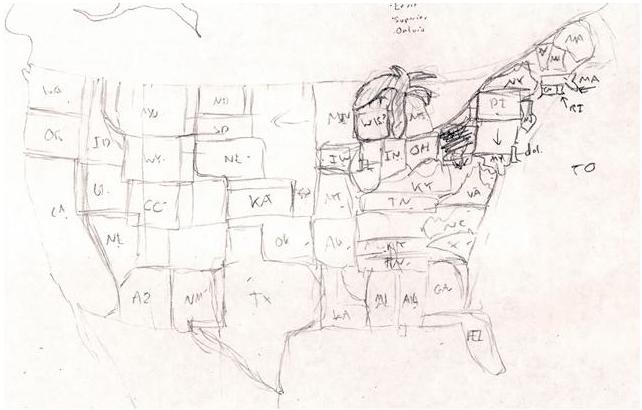
Rough sketch = epic fail.
Apparently, in my mind, the Midwest is an even bigger expanse of nothing than it is in real life, the Great Lakes are a palm tree, West Virginia is a scribble, and New England is experiencing severe continental drift along the state border lines.
So I tried again, using just my rough sketch for reference, and I think this is substantially better:
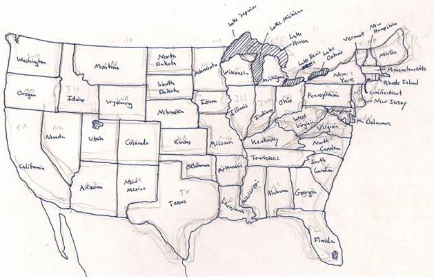
The proportions (and some locations) really start to suck east of the Mississippi River, but at least I didn’t miss anything. Indiana and Ohio look crappy ‘cause I screwed up that general area and just went with it. The rest look crappy ‘cause I don’t know what they look like…in particular, I couldn’t for the life of me remember how the hell West Virginia is shaped, so I just kinda threw it on there where there was a gap in the states yet and called it good. Hahaha, Wisconsin is so deformed, but I got the Great Lakes right (edit: I also just realized I forgot to put the tail on the “g” so it looks like I wrote “Lake Michican.” You’d be surprised how often I forget to complete letters before moving on to the next one. Or maybe you wouldn’t, it is me, after all).
I’d try to draw Canada, but pfft. I know the names of the provinces and territories, I know where BC, Saskatchewan, and Nova Scotia are, but that’s about the extent of my Canadian geography knowledge.
I also have no idea when it was the last time I looked at a US map, Canadian map…or a map of anything aside from the bus routes, for that matter.
So there you go.
Conclusion: I like square states.
SLEEPYHEAD THERAPY
Ah, United States, I’ve MISSED YOU.
Milk does not cost an obscene amount and I can get a crappy sandwich at a gas station for under $8. It’s not raining incessantly and there are fat guys everywhere. America…FUCK YEAH!
So I finally took a break from calculus today to check my email. Got a $16,000 scholarship for next year and some check waiting for me for $1,000. I have NO IDEA why I’m getting this random check, but I’m not going to complain.
And I just might buy a guitar with part of it. Damn you, Sean.
Today’s song: The Champions by Era
WOOOOOO no pants!
This is pretty snazzy. Couple of highlights:
– Most potatoes produced: Idaho (go figure)
– Most reported Bigfoot sightings: Washington
– Idaho and Montana shrink to almost nothing when you select to view the states sized by the number of African American individuals living in the state.
Yay Obama!
WOO!
Finally, a democrat is back in the White House.
Let’s see what you can do, Obama. I wish you luck.
Blog 426: Map-o-Rama!
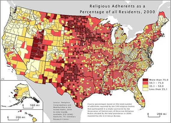
Two interesting maps for you to ponder. Soda and religion, what a combination!
That is all.
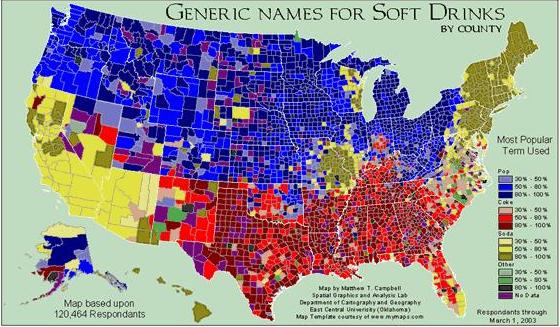
(Red is Coke, yellow is soda, and blue is pop, by the way)