IDES OF APRIL
Remember that map thingamapoop that you can color in based on where you’ve lived and how long you’ve lived there?
Probably not, ‘cause that’s not super descriptive or specific. So here’s mine from 2013.
Here’s the updated map to reflect my current state.
(Or province.)
(That was a really stupid joke, sorry.)

That’s…not as different from the 2013 one as I thought it would be, haha.
Slippery Slopes
So remember that post I did awhile back that talked about why we use “m” for slope? Well, I mentioned in it that some other countries use different letters. Here’s a handy dandy map of those different letters, based on this info.

So…consider this a follow-up blog?
Claudia Can’t Sleep
(Claudia can’t draw, either, but that won’t stop this blog from happening.)
Remember when I tried to draw the continental US without looking at a map?
Well now let’s try it with Canada! Apologies in advance. Rough sketch:

Oh gods. Manitoba has an oscillating border, Ontario is NOT SHAPED LIKE THAT, and I think I cut off like 6000 square kilometers from the east coast by Hudson Bay.
Let’s take the rough sketch and refine it a bit, eh?

Yeah, Ontario is still screwed up (the dangly bit that dips down into the US is a lot bigger than in the picture) and I have no idea what happens to the northern part of Nunavut (all I knew is that it breaks up in a triangle-like shape, haha), but I guess it could be worse.
Also, ever notice that a lot of the provinces resemble some US states (or vice versa I guess)?
Think about it:
- British Columbia is like a fat California.
- Alberta is like a stretched Nevada.
- Saskatchewan is North Dakota on its side.
- Manitoba is Minnesota with somewhat straighter eastern borders.
- Yukon is a giant New Hampshire.
- Nunavut is an upside down broken-up Texas.
Also, Canada has a hypothetical four corners like the US (Saskatchewan, Manitoba, NW Territories, Nunavut), but it’s in a super remote area and since the NW Territories/Nunavut boundary hasn’t been totally surveyed yet, they’re not sure if they meet at the corner of the Manitoba/Saskatchewan border.
Oh, Canada.
Maps (they don’t love you like I love youuuuuuuuuuu…)
Well this was cool to do.

What the colors represent:
- Red: states/provinces where I’ve not spent much time or seen very much.
- Amber: states/provinces where I’ve at least slept and seen some sights.
- Blue: states/provinces I’ve spent a lot of time in or seen a fair amount of.
- Green: states/provinces I’ve spent a great deal of time in on multiple visits.
I like how I’ve been all over the West Coast and the Great Lakes area, but very few other places (I went to Boston for that APS conference in May 2010; my grandparents used to live in St. Louis).
I also realized after making this that I’ve also been to Washington, D.C., but since that’s its own thing and not technically in a state, I decided to leave it as it is.
If you click here, you can make one of your own!
A STATELY CHALLENGE
Holy crap, it’s a blog not posted at 1 AM!
So while I was doing research today (read: “as R was working hard running my code and I was just sitting there”), I decided to see if I could draw the US and all the continental states from memory. First I made a sketch to see if I could even get close, then I made an actual drawing with ink so you could see all my little screw ups (aka, the entire eastern seaboard).
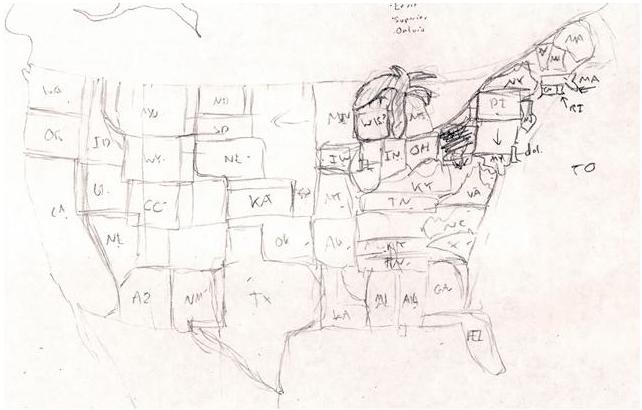
Rough sketch = epic fail.
Apparently, in my mind, the Midwest is an even bigger expanse of nothing than it is in real life, the Great Lakes are a palm tree, West Virginia is a scribble, and New England is experiencing severe continental drift along the state border lines.
So I tried again, using just my rough sketch for reference, and I think this is substantially better:
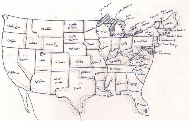
The proportions (and some locations) really start to suck east of the Mississippi River, but at least I didn’t miss anything. Indiana and Ohio look crappy ‘cause I screwed up that general area and just went with it. The rest look crappy ‘cause I don’t know what they look like…in particular, I couldn’t for the life of me remember how the hell West Virginia is shaped, so I just kinda threw it on there where there was a gap in the states yet and called it good. Hahaha, Wisconsin is so deformed, but I got the Great Lakes right (edit: I also just realized I forgot to put the tail on the “g” so it looks like I wrote “Lake Michican.” You’d be surprised how often I forget to complete letters before moving on to the next one. Or maybe you wouldn’t, it is me, after all).
I’d try to draw Canada, but pfft. I know the names of the provinces and territories, I know where BC, Saskatchewan, and Nova Scotia are, but that’s about the extent of my Canadian geography knowledge.
I also have no idea when it was the last time I looked at a US map, Canadian map…or a map of anything aside from the bus routes, for that matter.
So there you go.
Conclusion: I like square states.
Haha, woah.
So…we learned about Anaximander today in Ethics…this was his map of the world.
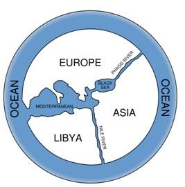
I love how Libya IS the African continent. I thought the Europeans were screwing around in Egypt by this point in time? Perhaps not.
Still though.

